| I&T Solution |
Adoption of AI Analysis on Traffic Data for Traffic Prediction and Management
(REF : S-1383)
|
| Trial Project |
|
| Solution Feature |
- Real-time traffic products are created by merging multiple data sources from over 600+ million connected devices. The model can then calculate travel times and speeds using highly-granular data gathered on every stretch of road. Data sources include probe and journalistic data, sensor-derived observations, community input, traffic moderation, speed profiles.
- The most critical data stream is GPS data received from various fleets, including navigation devices, automotive in-car systems from the biggest car manufacturers and very well known smartphone applications. Probe data is collected via the storage of GPS points at a one-second interval.
- Realtime data delivers information on current-observed congestion and road incidents. Traffic incidents include traffic jams, closed roads, lane closures, construction zones, accidents. These messages contain accurate positioning, delay, queue-length information. Realtime data offers a detailed view of the current observed speed and travel times on the entire road network.
- Our solution has been archiving the input location data for geospatial analysis since 2016 for Hong Kong. This archived GPS data is made available through different products and delivery methods. The products based on historical data allows you to go back in time and perform analysis
- Using the above-mentioned data, our integrate solution together with our AI functionality shall be able to provide analysis for traffic prediction and management
|
| Trial Application and Expected Outcome |
- Data Fusion / 數據融合 The data fusion module would go through various validations and data fusion steps to repeat the data fusion continuously in every 30 seconds.
- Live, historical traffic data can overlay on your map using our OpenLR technology. Clients can integrate with our traffic data using your data sources. Our OpenLR is a linear referencing system which allows dynamic relationship between our and your map map to automate process and allow use in third-party environments.
- Jam ahead and tendency warnings / 擁堵警告 The application can generate warning messages when a location registers high-speed differences. Precisely when the tail end of the jam is projected to intercept oncoming traffic, creating a potentially dangerous situation.
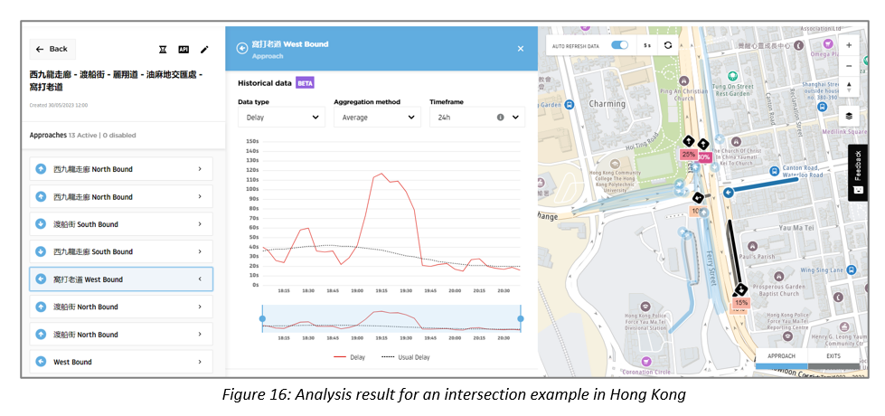
- Junction Analytics (Real Time) draws upon GPS data from half-a-billion connected devices. Via API this connects to rich, 24/7 real-time traffic data, without need for expensive hardware. Users can configure and visualize intersection locations, use intuitive analytics tools and reports to obtain detailed insights into signal performance and mobility patterns.
- Traffic Stat. (Historical Data), users create customized query for specific area or route, time periods in date-range specified. Results are computed and a report for view or download within a few minutes. Complicated query containing large area and wide date range will take less than 24 hours to generate results.
|
| Additional Solution Information |
Solution Proposal - Hong Kong EMSD.pdf
|
| Info on I&T Solution Provider |
| Solution Provider | : | Esri China (Hong Kong) Limited, TomTom |
| Address | : | 9th Floor, CEO Tower, 77 Wing Hong Street, Cheung Sha Wan, Kowloon, Hong Kong. |
| Contact Person | : | Tony Chan |
|
Position | : | Business Development Director, Sales & Marketing
|
|
Tel | : |
3768 5961
|
|
Email | : |
tchan@esrichina.hk
|
|
Webpage | : |
www.esrichina.hk
|
|